
Explore a comprehensive and exam-focused guide to the climate of Jharkhand—covering tropical monsoon characteristics, seasonal transitions (summer, monsoon, winter), rainfall distribution, temperature variations across cities like Ranchi, Jamshedpur, and Hazaribagh, and the classification of agro-climatic and regional climate zones—crucial for JPSC, JSSC, and other competitive exams related to Jharkhand Geography and Environment.
General Climate Type of Jharkhand
- Jharkhand experiences a Tropical Monsoon Climate (Ushnakatibandhiya Mansuni Jalvayu).
- The region is influenced by monsoonal winds, resulting in distinct seasons:
- Summer
- Winter
- Rainy Season
- The average annual temperature is around 25°C.
Major Climatic Influencing Factors in Jharkhand
- Latitudinal Position
- The Tropic of Cancer passes through the middle of Jharkhand.
- Results in a tropical climate, though subtropical effects are seen in higher plateau regions.
- Proximity to Sea
- The south-eastern region (like Dhanbad and Singhbhum) lies close to the sea.
- This increases humidity levels in these districts.
- Relief and Elevation (Topography)
- Jharkhand has a sloping plateau, descending from the pat region toward the north, east, and south.
- Moist winds from the Bay of Bengal rise along plateau edges and cause heavy rainfall.
- The north-western region (Palamu) lies in the rain shadow zone, making it drought-prone.
- Wind Flow Belt
- From June to October, south-west monsoon winds (Bay of Bengal branch) move southeast to northwest.
- Simultaneously, Arabian Sea winds bring rainfall to the western region of the state.
- Vegetation Cover
- Dense forests in Jharkhand contribute to evapotranspiration, creating a humid microclimate.
- This leads to local summer rainfall, often called instability rain (Linstability Rain).
Agro-Climatic Zones of Jharkhand
Jharkhand falls under Agro-Climatic Zone VII of India, known as the Eastern Plateau and Hills Region.
According to NIDM (National Institute of Disaster Management), Jharkhand is classified into three agro-climatic sub-zones:
| Agro-Climatic Zone | Districts Covered |
|---|---|
| I. Central and North-Eastern Plateau | Chatra, Koderma, Hazaribagh, Ramgarh, Bokaro, Dhanbad, Ranchi, Deoghar, Dumka, Pakur, Godda, Jamtara, Sahibganj, Giridih |
| II. Western Plateau | Garhwa, Palamu, Latehar, Gumla |
| III. South-Eastern Plateau | Lohardaga, Simdega, Khunti, East Singhbhum, West Singhbhum, Seraikela-Kharsawan |
Rainfall Distribution and Soil Characteristics (Zone-wise)
Central & North-Eastern Plateau
- Rainfall: 140–152 cm (Moderate)
- Rainfall Pattern: Late onset and early retreat of monsoon
- Soil Type: Sandy soil, black soil, eroded and alluvial soil
- Soil Characteristics:
- Low water retention capacity
- Major Crops: Paddy, wheat, maize, coarse grains
- Irrigation: Available via rivers
Western Plateau
- Highest elevation agro-climatic zone in Jharkhand
- Uneven rainfall distribution, some drought-prone areas
- More rainfall in the Pat regions
- Temperature: Higher generally, Netarhat remains cooler
- Soil Type: Laterite and red soil
- Soil Characteristics:
- High acidity
- Low retention and fertility
- Major Crops: Paddy, maize, wheat, pulses, oilseeds
South-Eastern Plateau
- Rainfall: 142–155 cm
- More rainfall in eastern areas
- Soil Characteristics:
- Low water retention
- Low productivity
- Vegetation: Region rich in dense forests
- Climate: Sea-influenced, with higher humidity
- Major Crops: Paddy, jowar, maize, wheat, coarse grains
- Irrigation: Primarily river-based
Seasonal Overview of Jharkhand’s Climate
1. Summer Season (March to Mid-June)
- Starts in March; peaks in May.
- Monthly temperature range: 29°C to 45°C
- Regions like Hazaribagh, Ranchi, Netarhat: 2°C to 5°C cooler
- Hottest month: May
- No major heatwave (loo) impact due to plateau geography.
- Jamshedpur is the hottest city in the state.
- The summer wind disturbance ends around June, locally called “Baishakhi”.
- In May, Nor’westers bring thunderstorms and rainfall, especially in eastern regions—also called Mango Showers (Aam ki Barish).
Exam-Focused Highlights
- Tropic of Cancer passes through Jharkhand – Repeated in JPSC/JSSC
- Rain shadow zone: Palamu – Often asked
- Highest elevation agro-climatic zone: Western Plateau
- Mango showers affect only eastern Jharkhand
- Jamshedpur is the hottest place in Jharkhand
- Major crops: Paddy, wheat, maize, pulses, oilseeds
- NIDM classification: 3 agro-climatic zones
General Climate Type of Jharkhand
- Jharkhand has a tropical monsoon climate.
- It experiences three major seasons: Summer, Monsoon, and Winter.
- The average annual temperature is 25°C.
- Jharkhand lies near the Tropic of Cancer, hence tropical climate predominates, with subtropical effects in plateau regions.
Factors Influencing Jharkhand’s Climate
- Latitudinal Location
- The Tropic of Cancer passes through Jharkhand, giving it a tropical climate.
- Higher altitudes in plateau regions exhibit subtropical climate characteristics.
- Proximity to the Sea
- Southeastern Jharkhand is relatively close to the Bay of Bengal, influencing humidity levels, especially in Dhanbad and Singhbhum.
- Relief Features
- The Pat region is elevated, while the northwestern plains (Palamu) lie in a rain-shadow zone, resulting in dry conditions.
- Moist air from the Bay of Bengal rises along the plateau steps, causing heavy rainfall in plateau regions.
- Wind Patterns
- Southwest monsoon winds flow from southeast to northwest between June and October.
- Arabian Sea branch contributes rainfall to western parts of Jharkhand.
- Vegetation Cover
- Dense forests create local humidity via evapotranspiration, causing light unstable rainfall in summers.
Agro-Climatic Zones of Jharkhand
Jharkhand falls under Agro-Climatic Zone VII – Eastern Plateau and Hill Region (As per NIDM).
Zones and Their Features:
1. Central and North-Eastern Plateau
- Districts: Chatra, Koderma, Hazaribagh, Ramgarh, Bokaro, Dhanbad, Ranchi, Deoghar, Dumka, Pakur, Godda, Jamtara, Sahibganj, Giridih.
- Rainfall: 140–152 cm (average).
- Soil: Sandy, black, eroded, and alluvial soils.
- Crops: Rice, wheat, maize, millets.
- Irrigation: Mostly river-based.
- Climate Feature: Late onset and early withdrawal of monsoon.
2. Western Plateau
- Districts: Garhwa, Palamu, Latehar, Gumla.
- Rainfall: Irregular; some drought-prone areas.
- Soil: Laterite and red soils; acidic and poor water retention.
- Crops: Rice, maize, wheat, pulses, oilseeds.
3. South-Eastern Plateau
- Districts: Lohardaga, Simdega, Khunti, East and West Singhbhum, Seraikela-Kharsawan.
- Rainfall: 142–155 cm (average).
- Soil: Low water retention; low fertility.
- Crops: Rice, jowar, millets, wheat, maize.
- Climate Feature: High humidity due to coastal influence.
Seasonal Climate of Jharkhand
1. Summer (March to Mid-June)
- Begins in March, peaks in May.
- Average temperature: 29°C to 45°C.
- Cooler areas: Hazaribagh, Ranchi, Netarhat (2°C to 5°C lower).
- Hottest place: Jamshedpur (45.0°C).
- No strong loo winds due to plateau geography.
- Local thunderstorm rains in May, known as Mango Showers (Norwesters), especially in eastern parts.
- Local term: Baishakhi wind flow.
2. Monsoon (June to October)
- Starts by mid-June.
- Pre-monsoon rains start after May 25, from the east.
- Main rainfall is from Southwest Monsoon winds:
- Bay of Bengal Branch: Primary source of rain.
- Arabian Sea Branch: Affects western regions.
- Rainfall decreases from south to north and east to west.
- Average rainfall: 140 cm annually (medium rainfall region).
- 80% of annual rain falls during this season.
- Most rainfall: Netarhat Plateau (180+ cm).
- Least rainfall: Chaiabasa plains.
- Rainiest district: Hazaribagh.
3. Winter (November to February)
- Starts in November, peaks in January.
- Average temperature: 15°C to 21°C.
- Colder in higher altitudes, sometimes as low as 3°C.
- Coldest place: Netarhat (Magnolia Point) (minimum 7°C).
- Light rains due to Western Disturbances – beneficial for Rabi crops.
- Frost formation common in extreme cold.
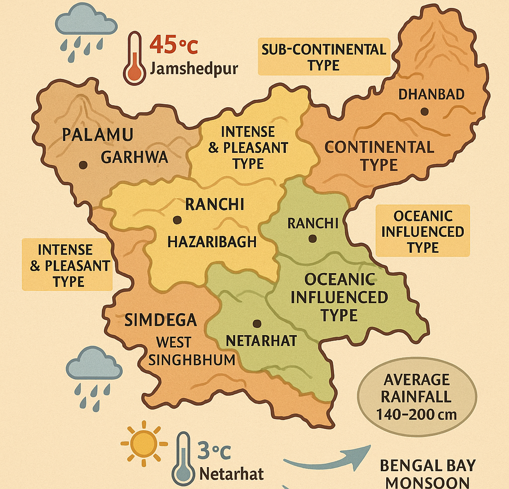
Climate Types in Jharkhand (By Ayodhya Prasad)
| Climate Type | Affected Area | Rainfall (cm) | Special Features |
|---|---|---|---|
| Continental Type | North/NW (Palamu, Garhwa, Chatra) | 114–127 cm | Hot summers, cold winters |
| Sub-Continental | Central parts (Latehar, Dhanbad) | 127–165 cm | Moderate temp, more rain |
| Delta Type | Eastern Santhal Pargana (Sahebganj) | ~152 cm | Similar to WB Norwesters |
| Sea-Influenced Type | East Singhbhum, Seraikela | 140–152 cm | High humidity, pre-monsoon storms |
| Wet Rain Type | Western Singhbhum, Simdega | 152+ cm | Both monsoon branches active |
| Pleasant & Intense | Ranchi, Hazaribagh Plateaus | 148 cm | Unique climate due to elevation |
| Cold Rain Type | Pat Region (Lohardaga, Gumla) | 203+ cm | High clouds, rainfall, even in winter |
🔺 This classification by Ayodhya Prasad divides Jharkhand into 7 climatic zones.
Important Exam-Oriented Facts (Frequently Asked in JPSC/JSSC)
Forests promote local unstable summer rainfall
Hottest City: Jamshedpur (45°C)
Coldest Place: Netarhat (as low as 3°C)
Most Rainfall: Netarhat Plateau (180+ cm)
Least Rainfall: Chaiabasa Plains
Best for Rabi Crops: Winter rainfall due to western disturbances
Pre-monsoon Showers: Norwesters (Mango Showers) in May
Rainiest District: Hazaribagh
Two Monsoon Branches: Bay of Bengal & Arabian Sea