
Jharkhand, a mineral-rich and forested state in eastern India, faces a complex array of natural and human-induced disasters, including frequent elephant attacks, forest fires, droughts, floods, and mining-related hazards. With a growing population and increasing human encroachment into forest areas, the need for a robust and responsive disaster management system in Jharkhand has become more critical than ever. This blog presents a detailed analysis of Jharkhand’s multi-tier disaster preparedness strategy, the formation and functions of the Jharkhand State Disaster Management Authority (JSDMA), and insights into district and village-level response mechanisms. The post also highlights major affected districts by various disasters, such as lightning-prone areas, earthquake zones, industrial accidents, and seasonal threats like cold waves and cyclones, making it an essential resource for JPSC, JSSC, UPSC, and other state-level competitive examinations. From mock drills and GIS systems to school safety programs and community awareness campaigns, this in-depth overview is your complete guide to understanding disaster resilience efforts in Jharkhand.
Classification of Disasters
- Natural Disasters: Caused by natural phenomena like earthquakes, cyclones, floods, tsunamis, droughts, etc.
- Man-made Disasters: Caused due to human activities such as wars, nuclear accidents, chemical explosions, etc., and are often termed social disasters.
Earthquake in Jharkhand
- Jharkhand is considered a low-risk zone for earthquakes.
- Based on seismic sensitivity, the state falls under Zone II, III, and IV.
| Zone | No. of Districts | Districts |
|---|---|---|
| Zone II | 07 | Ranchi, Lohardaga, Khunti, Ramgarh, Gumla, East Singhbhum, West Singhbhum |
| Zone III | 15 | Palamu, Garhwa, Latehar, Chatra, Hazaribagh, Dhanbad, Bokaro, Giridih, Koderma, Deoghar, Dumka, Jamtara, Godda, Pakur, Sahibganj |
| Zone IV | 02 | Northern parts of Godda and Sahibganj |
This classification has been asked in several Jharkhand competitive exams.
Floods in Jharkhand
- 11 districts are flood-prone: Sahibganj, Godda, Pakur, Dumka, Dhanbad, Deoghar, East Singhbhum, West Singhbhum, Hazaribagh, and parts of Palamu, Garhwa, Latehar (due to rising levels in Son and North Koel rivers).
- Major cause: Monsoonal rainfall leading to increased river levels.
- Impact:
- Damage to paddy crops and negative impact on food grain security.
- Destruction of houses, roads, bridges, etc.
- Transport disruption and spread of waterborne diseases, especially in Ranchi and Jamshedpur.
Drought in Jharkhand
- Drought is categorized based on rainfall deficiency:
- Normal Drought: 25% less rainfall
- Moderate Drought: 25–50% less
- Severe Drought: >50% less
- Disastrous Drought: <75% of normal rainfall
- Severely affected region: North-western Jharkhand — particularly Palamu, Garhwa, Latehar, Chatra, Lohardaga.
- Palamu is the most drought-prone district.
- In 2010, 12 out of 24 districts were severely affected (important exam fact).
- Mitigation measures:
- Construction of dams, ponds, dobas, and watershed management.
- Crop planning, soil conservation, afforestation.
- Training and awareness among locals.
Lightning (Tadit) Strikes
- Caused by lightning during rainfall, results in loss of human and livestock lives every year.
- Major affected districts: Palamu, Chatra, Latehar, Gumla, Ranchi, Giridih, Koderma.
- A special training module has been developed by Sri Krishna Institute of Public Administration.
- Safety training includes:
- Staying indoors during thunderstorms.
- Avoiding trees, poles, and open areas.
Mining Accidents
- Jharkhand holds 40% of India’s mineral reserves.
- Mining is crucial to the state’s economy but leads to several disasters:
- Mine collapse
- Worker entrapment
- Health issues from mining pollution
- Coal fires in areas like Jharia and Ramgarh
- Preventive Measures:
- Training of mine workers.
- Quick-response systems during emergencies.
- Use of protective gear like masks.
- Awareness campaigns about occupational hazards.
Forest Fires
- Forest fires play a major role in affecting Jharkhand’s forest ecosystem.
- State has large forest cover, mainly dry deciduous forests prone to summer fires.
- Causes:
- Friction between dry trees during strong winds.
- Use of fire by locals for mahua collection.
- Carelessness by tourists (discarding burning matchsticks).
- Fires peak during March–April.
- Most affected areas:
- North-western and south-western Jharkhand: Palamu, Latehar, Garhwa, Chatra, Hazaribagh, Simdega, Gumla
- Preventive Strategies:
- Strict tourism laws and penalties.
- Awareness about extinguishing fires post-use.
- Cutting old trees and planting new ones.
- Building fire watchtowers and forest roads for compartmentalization.
Elephant Attacks
- Elephant is the state animal of Jharkhand.
- Major habitats: Palamu, Dumka, Saranda (West Singhbhum), Hazaribagh, Dalma forests.
- Frequent incidents of elephant attacks reported, posing threat to human settlements and crops.
This has emerged as a serious man-animal conflict issue.
Key Exam Highlights
- Palamu: Most drought-prone and lightning-affected.
- 2010: Severe drought in 12 districts.
- Zone II, III, IV: Earthquake-prone divisions.
- Jharia & Ramgarh: Known for coal fires.
- March–April: Peak period for forest fires.
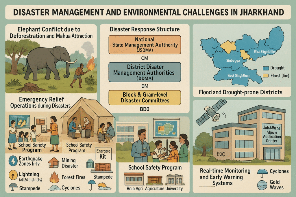
Elephant Attacks in Jharkhand: Causes and Control
- Primary Cause: Human interference in natural habitats of elephants.
- Deforestation and human encroachment have opened pathways for elephants into rural areas, forcing them out of their native forests.
- Attraction to fragrant Mahua flowers is another major reason for elephants entering human settlements.
- Districts commonly affected: Khunti, Simdega, Gumla, Latehar, Palamu, Chatra, and Hazaribagh.
Prevention and Community Response
- Awareness campaigns are essential to educate villagers not to interfere with elephant habitats.
- Common methods to drive away elephants include:
- Beating drums and playing loud sounds
- Lighting fires
- Using chili smoke
Disaster Management in Jharkhand
Disaster management in Jharkhand is organized into three phases:
1. Pre-Disaster Preparedness
- Involves planning, mitigation, and prevention measures.
- Includes:
- Understanding nature and scale of disasters
- Forecasting and early warning systems
- Spreading public awareness
2. During Disaster
- Focus on rescue operations, shifting people to safe zones.
- Provide basic needs: food, water, medicines, clothing.
3. Post-Disaster Recovery
- Includes:
- Rehabilitation of affected communities
- Reconstruction of damaged infrastructure
- Restoration of normal life
Institutional Setup for Disaster Management
🇮🇳 At the National Level
- National Disaster Management Authority (NDMA) under the chairmanship of the Prime Minister.
At the State Level
- Jharkhand State Disaster Management Authority (JSDMA)
- Established on: 28 May 2010
- Formed under: Section 14(1) of the Disaster Management Act, 2005
- Chairperson: Chief Minister of Jharkhand
- Members: Up to nine members
Key Objectives of JSDMA
- Planning and strategizing multi-level disaster responses
- Framing projects for reconstruction and rehabilitation
- Development of infrastructure and communication networks at state, district, block, and panchayat levels
- Using GIS (Geographic Information Systems) for disaster mitigation
- Promoting awareness, issuing guidelines, and conducting training programs
Jharkhand Disaster Management Plan (2009)
- Disaster Management Department established: October 2004
- Primary goal: Immediate relief to disaster-affected people
- State Disaster Response Fund:
- Funding split: 75% Central Government, 25% State Government
- Emergency Operation Centers being set up in all districts under NDMA
- These are connected via V-SAT (satellite communication) for real-time coordination
National Disaster Response Force (NDRF) & SDRF
- NDRF formed in 2006 for national-level rescue and relief operations
- State Disaster Response Force (SDRF) set up at the state level for quick mobilization
- Disaster management training provided by Sri Krishna Institute of Public Administration (SKIPA), Ranchi since 2005
- ‘School Safety Program’ launched in 2015 with support from National Disaster Management Institute
Technology Support in Disaster Management
- Jharkhand Space Applications Center (JSAC):
- Provides remote sensing and mapping information during disasters
- Disaster Knowledge-Cum-Information Demonstration Center (‘Srujan’):
- Raises public awareness about different types of disasters
- Introduces people to new technologies and equipment for disaster preparedness
- Focus areas: floods, droughts, mining disasters, forest fires, etc.
Disaster-Related Institutions in Jharkhand
| Disaster Type | Associated Institution |
|---|---|
| Drought | Birsa Agricultural University, Ranchi |
| Mining disasters | Indian School of Mines, Dhanbad |
| Earthquakes | Birla Institute of Technology (BIT), Mesra |
| Flood, Drought, Forest Fire | Jharkhand Space Application Center (JSAC), Ranchi |
| Industrial Disasters | MECON, Ranchi |
| Public Awareness | Srujan Knowledge Center |
District Disaster Management Authorities (DDMAs)
- Formed in all 24 districts
- Chaired by: District Magistrate / Deputy Commissioner
- Members include:
- Chief Medical Officer
- Chief Engineers of water & irrigation departments
- Veterinary officer
- NGO representatives
- Responsibilities:
- Formulate district disaster plans
- Coordinate training of disaster response teams
- Promote public awareness on disaster mitigation
Block and Village-Level Disaster Management
Block Level:
- Committee chaired by: Block Development Officer (BDO)
- Members include health officials, fire services, NGOs, and local leaders
- Conducts mock drills and local planning
Village Level:
- Chaired by: Mukhia of Gram Sabha
- Responsible for:
- Creating and executing village-level disaster plans
- Spreading awareness through demonstrations and training
Disaster-Vulnerable Zones in Jharkhand
| Disaster Type | Affected Districts / Zones |
|---|---|
| Earthquake | Zone II – Ranchi, Khunti, Ramgarh, Lohardaga, Gumla, E. & W. Singhbhum (7 districts) |
| Zone III – 15 districts incl. Palamu, Chatra, Hazaribagh, Dhanbad, Giridih | |
| Zone IV – Northern Godda & Sahibganj (2 districts) | |
| Drought | All 24 districts; severe in Garhwa, Palamu, Chatra, Simdega, etc. (Last major: 2015) |
| Flood | Most affected – East & West Singhbhum, Ranchi, Koderma, Dhanbad, Dumka, etc. |
| Lightning | All 24 districts; highly impacted: Chatra, Palamu, Simdega, Gumla, etc. |
| Forest Fires | Garhwa, Palamu, Chatra, Gumla, Singhbhum, Simdega, etc. |
| Mining Disasters | Dhanbad, Bokaro, Ramgarh, Ranchi, Hazaribagh, E. Singhbhum, etc. |
| Industrial Disasters | Ranchi, Hazaribagh, Bokaro, Dhanbad, Ramgarh, Giridih |
| Cyclones | Eastern districts like Singhbhum, Ranchi, Simdega, etc. |
| Cold Waves | All 24 districts affected |
| Fire Incidents | Reported in all districts |
| Stampede & Crowd Disasters | Devghar (notably during pilgrimage events) |